| |
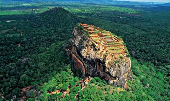
Sigiriya rock fortress Sri Lanka |
| |
|
Sri Lankan architectural custom is well exhibited at Sigiriya, the best preserved city centre in Asia from the first millennium, with its grouping of buildings and gardens with their trees, pathways, water gardens, the fusion of symmetrical and asymmetrical elements, use of varying levels and of axial and radial planning.
The Complex consists of the central rock, mounting 200 meters above the surrounding plain, and the two rectangular precincts on the east (90 hectares) and the west (40 hectares), bounded by two moats and three ramparts.
The plan of the town is based on an accurate square module. The plan expands outwards from co-ordinates at the centre of the palace complex at the top, with the eastern and western axis straightly aligned to it.The water garden moats and ramparts are based on an 'echo plan' duplicating the plan and design on either side. This town still exhibits its skeletal layout and its important features. 3 km from east to west and 1 km from north to south, it displays the grandeur and complexity of urban-planning in 5 th century Sri Lanka . The entrance to the western zone lies across the inner moat. It had an elaborate gatehouse made of timber and brick with a cemented roof. The moat is completely aligned with a mountain peak in the distance.

Only the southern side of the garden has been excavated, leaving the similar northern half for the archaeologist of the future. In the whole Sigiri-Bim, over 200 village tanks and rural sites have been examined.The water gardens of the western sector are symmetrically planned, while the rock garden at a top level is asymmetrically planned. The water garden shows one of the world's most sophisticated hydraulic technologies, dating from the Early Historic Period.
This shows an interconnection of macro- and micro-hydraulics to supply for domestic horticultural and agricultural needs, surface drainage and erosion control, decorative and leisure watercourses and retaining structures and cooling systems.
The Macro system consists of the Sigiri Maha weva, the man-made lake with a 12 km dam, running south from the base of the rock, a sequence of moats, two on the west and one on the east fed from the lake. At micro level are, the water control and the water retaining systems at the peak of the rock and at various levels with horizontal and vertical drains cut in to the rock and underground conduits made of cylindrical earth pipes.
|
![]()


